Directions to BRCC
By car, from the north
By car, from the south
By bus, rail, and taxi
By bicycle
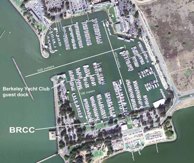
Detailed marina map
Berkeley Yacht Club's large-scale marina and off-ramp map with driving route
Berkeley Yacht Club's printable large-scale map with driving routeFROM THE NORTH
Route 880 south (also called 80 west or 580 east, but it really goes south) to Berkeley, exit at University Avenue. The exit ramp makes a 180 degree turn to the right, so that you are headed north at the stopsign. Turn left onto U. Ave., so that your are going west towards the bay.
Pass Seabreeze Market on your left. Keep going to the Marina entrance, where U. Ave. makes a slight turn to the left and then straightens again. Do not make a right turn until you are at the last parking lot entrance on the right before the road ends at the Municipal Fishing Pier and the Chinese Dog Warrior sculpture, which are at the extreme west end of U. Ave.
Car break-ins are sometimes a problem, so do not leave valuable items anywhere in the car.
FROM THE SOUTH (and from the Bay Bridge)
Route 880 north (Also called 80 east or 580 west, but it really goes north) to Berkeley, exit at University Avenue, right under the arch-suspension pedestrian bridge.Follow the signs to Frontage Road and then to Fourth Street. You will end up making three right turns taking you to the westbound freeway overpass, as described in more detail in the next three paragraphs.
The off-ramp itself can be confusing and is poorly marked. Immediately after exiting to the right, the off-ramp splits. Stay to the right at the first split, following the first sign to Frontage Rd. Do not take the left-most branch of the off-ramp that goes uphill to the University Avenue overpass.
A few feet later the off-ramp splits again. Both branches go down to street level. This time take the one to the left, following the signs to Frontage Rd. and Fourth Street. (Don't panic if you get this wrong. Either of the two incorrect branches of the off-ramp will lead to eastbound University Ave. If this happens, make a U-turn at 6th or 7th and pick up the directions again at the overpass.)
After the off-ramp, continue one short block north on Frontage Road under the University Ave. overpass, and take the first right turn about one block past the overpass onto Hearst, following the Fourth Street sign. Go about five blocks east, across the tracks and across Fourth Street, to the traffic light at 6th. Turn right on 6th, go south one block, then turn right onto University Ave., heading west.
Continue west on the overpass towards the Bay, over the railroad tracks and the freeway.
Pass Seabreeze Market on your left. Keep going to the Marina entrance, where U. Ave. makes a slight turn to the left and then straightens again. Do not make a right turn until you are at the last parking lot entrance on the right before the road ends at the Municipal Fishing Pier and the Chinese Dog Warrior sculpture, which are at the extreme west end of U. Ave.
Car break-ins are sometimes a problem, so do not leave valuable items in view.
BY BUS
The marina is served by the 51B bus line of Alameda/Contra Costa Transit (AC Transit). Make sure the bus says "Marina," otherewise it will terminate at the Amtrak station, a 15 minute walk to the marina (use the pedestrian overpass at the foot of Addison Street). Get off the bus at the stop for the Marina office, the fish boat dock, Cal Sailing Club and Adventure Playground. You'll see small boats and windsurfers on the left and Hana Japan restaurant on the right. If you miss this stop, the next stop is the end of the line, a short distance past M-dock at the Municipal Fishing Pier. Walk east, back in the direction you came along University Ave, to the M-dock parking area. Busses run approx. every 30 minutes between approx. 7 am and 8 pm every day. Call AC Transit at 510-839-2881 for bus schedule and routing details, or follow the link to the web based transit route planner.
BY RAIL (and bus or taxi)
The Richmond line of Bay Area Rapid Transit (BART) intersects the #9 bus line in downtown Berkeley. Get off at the Downtown Berkeley BART station (not at North Berkeley) and use the main exit (the escalator faces west as you leave the station). Walk east across Shattuck Avenue to the bus stop on the south-east corner of Shattuck and Center. The 51B bus will be going north on Shattuck Avenue. Make sure you catch a 51B "Marina" bus and not a 51B "Amtrak" bus. The Amtrak stop is under the freeway and it's a 15 minute walk from there to the marina.
The bus stop is directly in front of a store called "Games of Berkeley," offering superb browsing while you wait.
If you have arranged for someone to pick you up from the BART station by car, the North Berkeley BART station is slightly closer to the marina but is in a residential area with no commercial activity. (You can catch the 51B Marina bus from North Berkeley BART by walking a few blocks south along Sacramento to University Avenue). Be sure to clarify which station you are waiting at if you are being picked up by car.
Taxis are generally available near the main entrance to the downtown Berkeley and North Berkeley BART stations. Taxi fare to the marina is about $10 and a 15-20% tip is customary.
There is an Amtrak stop in west Berkeley, underneath the University Ave. overpass just east of the freeway. From here it's about a 15 minute walk to BRCC or 20 minutes to BYC. Or a short taxi ride. There are about 12 trains per day in each direction stopping at Jack London Square, Emeryville, Richmond, and points north and South.
BY BICYCLE
There is a bike/pedestrian overpass that crosses the freeway just south of the University Ave. overpass.To find it, ride west on Addison Street (parallel to and one block south of University Avenue) almost all the way to the end, to the lake at Aquatic Park. Ride a short distance around the north end of the lake to the overpass ramp. You can also get to Frontage Road via Gilman Street, about 3/4 mile to the north. A new bicycle path, part of the Bay Trail, was added to this section of Frontage Road in 1997. This is now the preferred approach from the north.
The bike/pedestrian route may not be safe after dark. If you are at a practice that ends late, please ask someone to give you and your bike a ride to the east side of the overpass.