Latitude 38
|
Latitude 38
|
|
This is the article I wrote for the regional sailing magazine Latitude 38 in 1983. It appeared in the December issue.
I think most of us on the Design Charrette team would have scaled back our proposal quite bit if we could have anticipated the success that the Sierra Club, CESP, and others would ultimately have in getting these lands into public ownership.
Have you ever sailed into Berkeley's "North Sailing Basin"? That's the body of water bounded by the city dump on the west, the freeway and race track parking lot on the east, and a large vacant lot on the south. It's a good bet that you haven't. Between the smell from the dump and the noise from the freeway (not to mention the four- to five-foot depths at low tide), it's no surprise to find that this cove Isn't mentioned in any of the cruising guides. But in just a few years, what is now the unchallenged domain of a handful of semi-abandoned yachts and an occasional reclusive liveaboard could be transformed into the focal point of one of the most heavily developed waterfronts on the Bay.
West Berkeley has a long history as a waterfront community. Originally called Ocean View, much of the town's commercial, residential, industrial, and even recreational activity was closely linked to the Bay. It was the kind of small scale mixed land use that characterizes some of the most interesting waterfront towns, and it evolved in a pre-automotive society without benefit of planners, landscape architects, or urban designers.
First the rail lines, then the East Shore Highway, and finally the freeway put an end to this relationship between West Berkeley and the Bay. The Berkeley Yacht Harbor, built entirely on bay fill, continued the City's maritime tradition in a very much altered form. The Marina reached its 900 berth capacity in 1973 and now includes a 300 room hotel, four restaurants, a boat yard, yacht club, several sailing clubs and schools, and the half-mile long Berkeley Fishing Pier. Currently under development is the "North Waterfront Park", 90 acres of dramatically contoured land covering the old city dump immediately to the north of the yacht harbor.
As far as most of Berkeley is concerned, the Marina and North Waterfront Park complex is an island. It bears little geographical or cultural relationship to the rest of the town, and although not completely surrounded by water, the land bridge leading out to it consists of a wide expanse of open, undeveloped property.
This property, and virtually all the remaining land, water, and mud in a 2,000-4,000 foot wide strip west of Route 17 between Richmond and the Bay Bridge, is owned by the Santa Fe Land Improvement Company. Clearly, the original intent behind Santa Fe's acquisition was industrial development on bay fill. But the rising public sentiment against bay fill in the fifties led to the formation of groups such as Save The Bay and ultimately BCDC (Bay Conservation and Development Commission), which effectively halted filling of the Bay. Ever since, the fate of Santa Fe's land has been seriously in doubt. In 1970 the company proposed to develop a major regional shopping center (aka Hilltop Mall) on the 73 acre parcel immediately to the east of the yacht harbor, but this was successfully blocked by the newly formed Berkeley Bayfront Council . Santa Fe sued, and the case is still unresolved.
Now, amid a climate of related court decisions in which public trust arguments have had increasing importance, Santa Fe has expressed a new willingness to cooperate with city government. At the same time, the Coastal Conservancy, a state agency charged with funding and implementing public access waterfront projects throughout the state, has turned its attention to the East Bay shoreline. Over two years ago the Coastal Conservancy began a series of workshops, surveys, and studies. The City of Berkeley began Its Own series of public workshops earlier this year.
Imagine what these workshops are like: Representatives from groups including People for Open Space, Berkeley Bayfront Council, Sierra Club, and East Bay Regional Parks District, advocate the preservation of the entire shoreline as recreational open space or protected wildlife habitat. Santa Fe wants to maximize profitable development. A large contingent of architects and planners each bring in their own set of issues, goals, and policies. Add to this the special interests of diverse organizations such as Cal-Trans, the Berkeley Beach Committee, South Berkeley Economic Development Association, and the Cal Sailing Club, among others, and the depth and breadth of the various opinions and arguments expressed at these meetings becomes apparent.
Two major plans have emerged so far, one from Santa Fe and one from the Coastal Conservancy.
The Santa Fe Plan
Early last month, Santa Fe unveiled its grand design for the
waterfront. To characterize it as "intense development' is an
understatement. The plan calls for 1500 Hotel rooms and three
million square feet of office space (downtown Berkeley now has
only one and one-half million square feet of office). All the
development is to be contained in an L-shaped pattern along the
east and south shores of the North Basin, the body of water
between the freeway and the North Waterfront Park. The buildings
and parking structures could be as high as 100 feet (ten
stories).
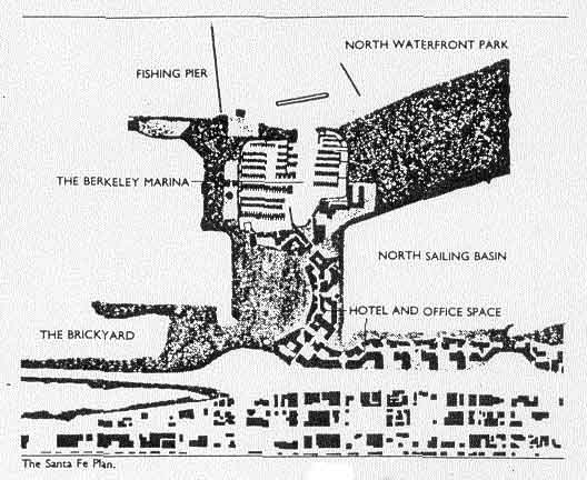
The plan does contain some important positive elements. Critical tidelands in Emeryville and Albany would be dedicated to public ownership, which would insure their preservation as wildlife habitats. The "Brickyard," a 27-acre filled area south of University Avenue, highly valued by open space and beach advocates, would also become public property. And five acres to the immediate east of the yacht harbor would be dedicated to a public development corporation, which presumably would go for development of an assortment of public serving activities.
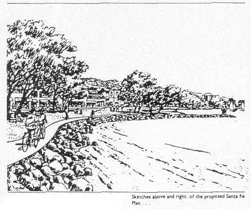
Santa Fe's treatment of the shoreline itself is not necessarily undesirable. BCDC's 100 foot jurisdiction is respected, and considerably widened in some places. The water's edge is green and park-like, with bicycle paths, a scenic waterfront drive, a boardwalk, and even a small boat rental facility. The row of structures between the freeway and the shoreline would have the effect of blocking the sights and sounds of the freeway - which most Marina users agree is currently the area's worst environmental detraction.
The major problem with Santa Fe's plan - aside from its sheer
scale - is the almost single-purpose use that it proposes. Any
commercial activity along the shoreline of the North Basin would
be primarily of the type that serves office users or hotel
guests. There is little to distinguish it from San Francisco's
Embarcadero, and nothing but the street names to relate it to
the rest of Berkeley. Access to North Waterfront Park is hidden
behind hotels and office buildings.
Even the public-oriented activity center is somewhat - misplaced. Santa Fe's planning consultant has explained that the principle way for non-yacht owners to enjoy the waterfront is as spectators of the Marina activity, or possibly by taking a ferry ride. This philosophy tends to underestimate the importance of small boat sailing. What about windsurfing? Rowboat rentals? Cooperative sailing clubs? It would make far more sense to leave the yacht harbor as it is, and orient the center of new public activity around the North Basin, an ideal location for small boat sailing, rowing, and windsurfing.
But a more basic objection to Santa Fe's plan is that it does
not really bring Berkeley to the waterfront. Without housing,
and without the diverse commercial and social services that
24-hour residents would support, the waterfront becomes an office
ghetto - jammed with 6,000 cars during the day, deserted and
dangerous at night. The open space areas tend to be viewed as
the front yards for the hotels and offices, and West Berkeley
remains as isolated from its waterfront as ever.
On the other hand, and in all fairness to Santa Fe, their proposal is a starting point for negotiation, and is naturally based on maximizing profit for the landowner. Also, the only economically feasible form of housing on the site would be relatively expensive condominiums, and this may well be politically unpalatable in Berkeley. Santa Fe has expressed a willingness to contribute to housing subsidies, but accurately points out that such subsidies are spent far more effectively in locations other than the waterfront. So housing, considered by some to be the key ingredient for creating a viable waterfront community, has been omitted.
The degree of subdivision is also a problem. Santa Fe intends to retain ownership, acting as "master developer" (the political implications are enormous). Subdivision into many small parcels, with land sales to individual owners, would likely result in much more interesting and varied uses, aside from keeping all the architectural eggs out of one basket.
The Coastal Conservancy's Design Charrette
Meanwhile, back in the public sector, the State Coastal
Conservancy had put together a team of architects, landscape
architects, and Urban planners. Their task was to spend one
weekend studying the site, examining the results of the public
workshops, and producing a plan. The event was called a "Design
Charrette," an obscure term used by architects which means
"workshop/brainstorming session with graphic output." The result
is an interesting alternative to Santa Fe's proposal.
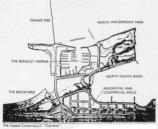
Like the Santa Fe plan, the Design Charrette shows a relatively large percentage of the waterfront lands being developed for private use. But the nature and orientation of the private use is very different. The Charrette team quickly picked up on the concept of the Marina and North Waterfront Park as an "island," and defined an urban "shoreline" to the east which leaves this feeling intact. They also re-configured the Brickyard into a more natural looking beach, and left a wide open-space corridor from the beach to the North Waterfront Park.
The fundamental difference is in the mix of uses - residential, commercial, office, and hotel - that the Charrette team considered most desirable. Grappling early on with the difficulties of making an area dominated by private development seem attractive and inviting to public access, they mapped out a very fine mesh of closely spaced local streets. Although there is community sentiment for restricting the shoreline road to pedestrians and bicycles, the Charrette team's reasoning is that free vehicular circulation is critical to avoid giving the impression to outsiders that the waterfront might be in someone's (or some company's) backyard. Equally critical is the requirement for housing - 1200 units being estimated as the number required to sustain the mix of neighborhood stores and shops that would make this community more than just another tacky tourist trap.
It was also recognized here that the housing would, out of
economic necessity, be upper-middle income, and that housing
subsidies would be better spent in other parts of town. This
presents obvious political difficulties in Berkeley, but the
Charrette team considered housing so important to enliven,
enrich, and de-sterilize any waterfront development that they
chose to fly in the face of perceived political constraints. One
architect, after being questioned by a City Council member about
the "exclusive" nature of the housing, explained that he firmly
believed the public at large would be better served by a
waterfront which had full-time residents, even if all of the
residents were wealthy. (Houseboats had been suggested as a
possible lower-middle income housing altemative, and the idea
actually received favorable response at public workshops and on
surveys. But then there's BCDC to contend with . . . )
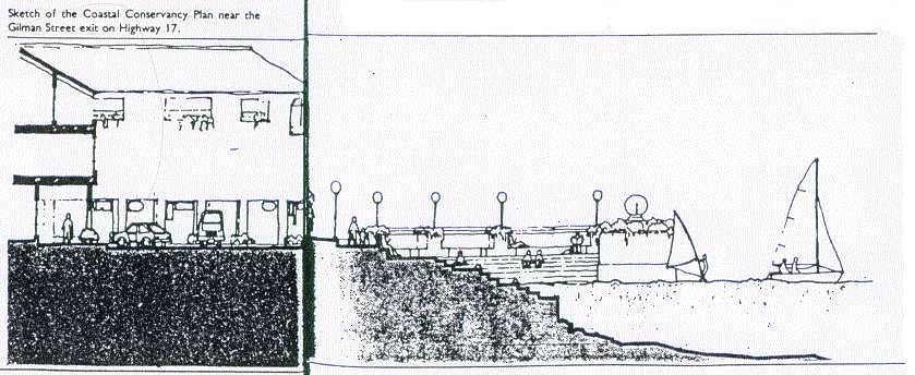
Like Santa Fe's proposal, the Coastal Conservancy Charrette plans include a conference center and major hotel development. One of the hotels, however, is located south of University Avenue on the east half of the Brickyard/beach area. This is to take advantage of the buffering effects of structure. By blocking the visual and sound impact of the freeway, the quality of the beach could be vastly improved - provided the access details are handled in a way which makes it clear to the public that the beach does not "belong" to the hotel. The hotel (which is not necessarily a conventional hotel - other visitor-serving facilities might be feasible) would be limited to about two stories in height. The developer, in return for being permitted to use this prime site, would contribute the funds necessary to construct the public beach.
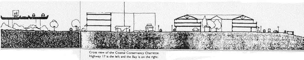
Building heights throughout the area would be far more modest
under the Charrette plan: two to three stories for the
residential/commercial area along the North Basin, three to four
stories for the office structures along the freeway, and a
maximum of five to six stories at the Gilman Street entrance.
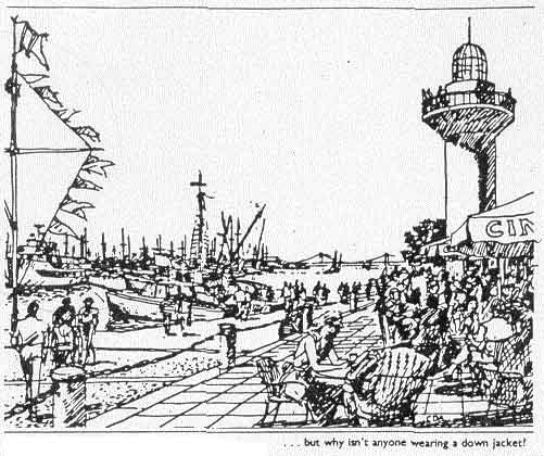
Images of certain European waterfronts had an influence on the Charrette Team and could have been the source of much of their enthusiasm for bringing the "urbarn edge" right up to the water. Searching for a characterization more relevant to the Bay area, they suggested that the new waterfront be described as "Sausalito-like," but this was rejected as being a little too un-Berkeley. "A cross between the Sausalito waterfront and the Berkeley Fishing Pier" was how one participant finally described it.
Both Santa Fe's proposal and the Design Charrette plan are somewhat deficient in that they fail to recognize the full potential of the North Basin (now referred to by some people as "Ocean View Cove") for small boat sailing and especially windsurfing. Considering the explosive growth of windsurfing and the scarcity of sites which combine a large protected area (with steady wind) for beginners with access to the Bay for the experts, it is likely that this cove will become one of the Bay Area's most popular launching spots. Sailboard and small boat shops, schools, rental facilities, and clubs, however, will never be as economically attractive as the more lucrative private developments with which they must compete for shoreline space, unless land is set aside specifically to support these activities.
Still to be reckoned with are the open space advocates who are adamantly opposed to the scale of development suggested by the Coastat Conservancy Charrette. Santa Fe's plan, of course, is considered even more outrageous. They maintain that as much of the property should be preserved for open space as possible, and any development that does not directly serve recreational or cultural purposes is at best a concession to economic realities. The social benefits of open space In close proximity to other uses seems to go unrecognized.
Interestingly, much of this sentiment comes from people who are not active users of the waterfront. Many of the most outspoken open space advocates are the same people who created Save San Francisco Bay and the Berkeley Bayfront Council, the people who stopped the Bay from being filled, and prevented Hilltop Mall from going in right next to the Marina. They deserve a great deal of credit and respect for these crusades. Somehow over the years, it seems, they lost sight of the fact that the real open space resource Is not the land, but the water. The sailors and windsurfers, on the other hand, tend to align themselves more or less with the pro-development side, in recognition of the fact that many types of private uses of waterfront land have the end result Of increasing public use of the waterfront. Could this be because the open space that's most important to the active users - the water surface - is not at all threatened by commercial activity on shore?
0f course there are many exceptions to such a broad generalization about who favors what. But the correlation is there. People who most frequently experience the waterfront as the view from a car or bus window see it very differently from those of us who are out on the water looking back at the cars and trucks on the freeway.
Over the next few months, the City of Berkeley will be formulating the framework within which the waterfront plan will be constructed. The potential exists to create an urban waterfront with incredible social and economic value. From the offshore perspective, this requires the integration of private and public uses, of open space and developed space, in a way that supports active use of the Bay for the largest number of people. If this perspective is well represented, we can look forward to the Berkeley waterfront becoming one of the highlights of the Bay's shoreline.
paul kamen