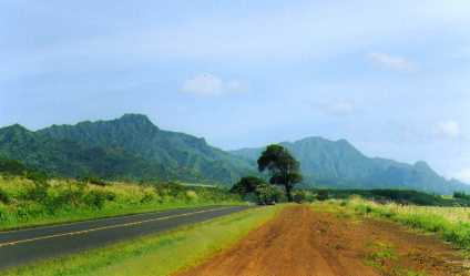
Mt. Kahili on the left, Mt. Waialeale on the right
True, Kaua'i is likely the most wonderful of the Hawaiian Island chain. It made the project more amazing than I could ever describe. It was very tough work, 12 hour days, 7 days a week non-stop for 120 days. Everything seems in slow motion in the tropical air, and construction projects wind up in their own schedule, despite one's best efforts.
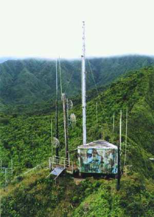
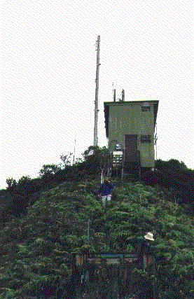
Above, the transmitter building and the main tower at Kahili.
The tower is a large wooden pole, heavily guyed to withstand high winds.
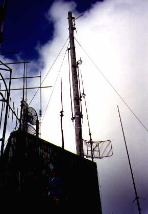
Below, the tower and the Shively 6813-2 antenna system.
The Mount Kahili electronic site is one of the most remote tower locations in the Hawaiian Islands. Road access is limited (in good weather) to very high-clearance 4-wheel drive vehicles only, and one can only drive within about a mile below the tower. From the end of the road, a one hour hike up a steep, razor-like ridge covered with wet Hawaiian ferns, and finally a 30 ft. rope leads you to the summit and the electronic site. For the Kekahu construction project, we hired Jack Harter, the most experienced helicopter pilot on Kauai. With over 35 years of experience, and 25 years with landing at the sometimes treacherous Kahili ridge, we were in good hands. We made many trips to the mountain, including a couple of freight hauling flights with racks, antennas, coax, transmitters and all the other things needed to put KAQA on the air.
Pictured here (on the left) are Roy Richardson, Jim Barnes and John Hawthorne, all waiting below the transmitter building for the helicopter to come retrieve them from Kahili and the increasing afternoon cloud cover. As the animation shows, 2 minutes can make a difference, as the clouds began to move back in right after we called to be picked up. 20 minutes later, the clouds made helicopter access impossible until the next day. Fortunately, everyone made it out safely just in time. It is typical during the summer to find Kahili in the clouds until about 10:00 AM, and after 4:00 PM you risk being stuck until the next day. Because of the elevation (nearly 3,000 feet above sea level), the winds and clouds are unpredictable. The weather in Lihue can be sunny and bright, while Kahili can be shrouded in clouds with less than 20 feet of visibility. The average yearly rainfall exceeds 300 inches, making this one of the wettest transmitter locations in the world. Despite these drawbacks, Mt. Kahili is the best electronic site on Kauai, due to it's look-angle to most of the populated areas around the island.
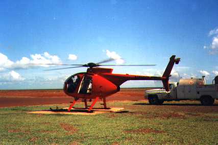
More recently, KKCR has been using Inter-Island Helicopters, located at the South Shore near Port Allen. Show here is one of their high-speed choppers, which make a quick trip to Kahili. It's a little wild, however, as there are no doors or side windows, so you are right out in the weather. The views are tremendous, however.
You can follow this link to a short animation of what it looks like to land and take off at Kahili. And you can follow this link to a short animation of a fly-by of the site.
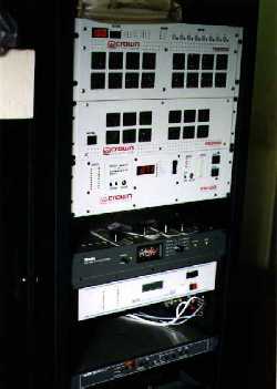 Shown on the right is the 91.9 FM transmitter, along with microwave interconnect
and remote control equipment. We chose a Crown 2,000 watt transmitter because of it's
good track record in other tropical environments, and also because it weighs less than
70 pounds. Larger transmitters could not be transported by helicopter.
Shown on the right is the 91.9 FM transmitter, along with microwave interconnect
and remote control equipment. We chose a Crown 2,000 watt transmitter because of it's
good track record in other tropical environments, and also because it weighs less than
70 pounds. Larger transmitters could not be transported by helicopter.
The picture below on the left shows the Kanaele Swamp, just west of Mt. Kahili. The County of Kaua'i electronic building is at the bottom of the picture, with Waiamea Canyon just visible in the distance.

© 2000 Broadcast Engineering Services of Bonny Doon