Eastshore State Park Preliminary Site PlansThese plans are preliminary, hypothetical, and works in progress. It is recognized that many details will change as they are developed.The photos used for the base maps are available from www.acme.com/mapper, an excellent front end for the USGS server. At this scale, one pixel is one meter in size. Printing at 152 dpi will result in a scale of 1"=500', the same (too-small) scale used by maps distributed by the planning consultants. |
|
|
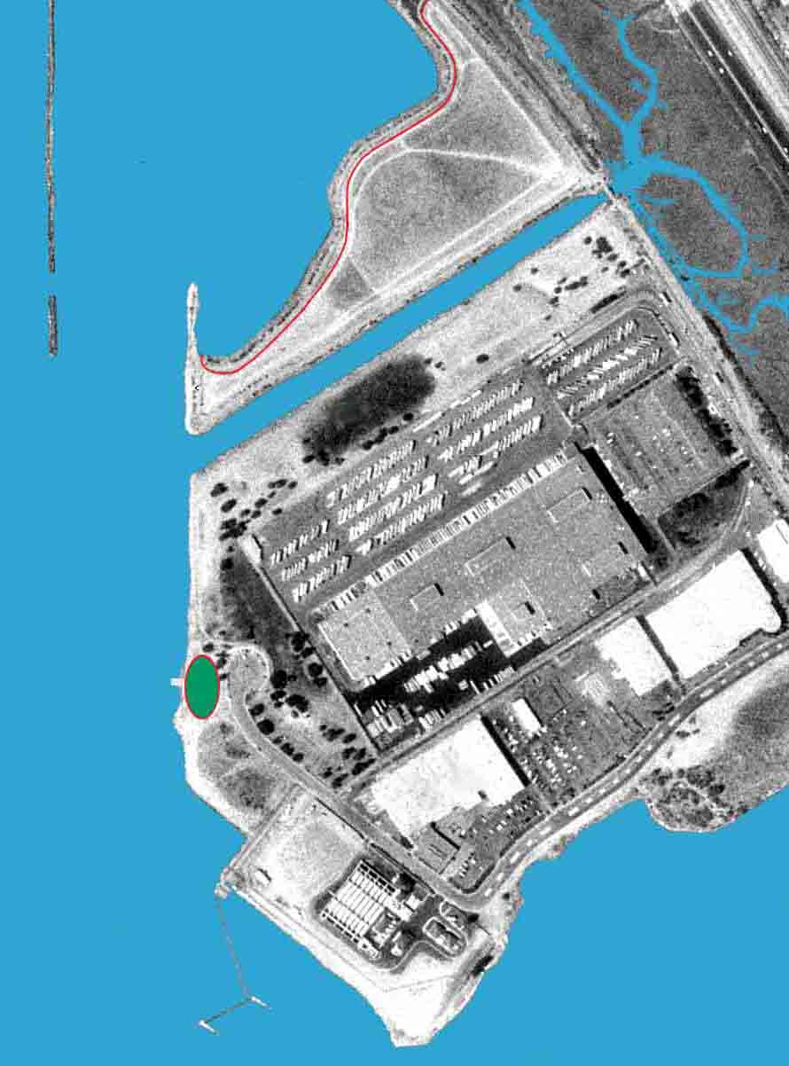
Point Isabel, including "Battery Point" or North Point Isabel
The red line separates the off-leash dog area from the sensitive tidal flat to the north. This "fence" could be informational or physical, but will probably be both. A low wood fence would probably be sufficient in conjunction with good signage. The windsurfer launch area is shown as a set of tidal steps, similar to the very simple and very popular facilities in Shimada Friendship Park near Marina Bay in Richmond. The rigging area has a red line around it indicating another barrier, informational or physical, to keep dogs off this one patch of grass. Maybe it doesn't need to be that big, but some of the windsurfers really do need better separation between their rigging area and off-leash dogs. This plan shows a new cut in the detached breakwater off the point. The detached end is big enough to be another camping stop along the Water Trail, without disturbing birds on the rest of the breakwater. |
|
|
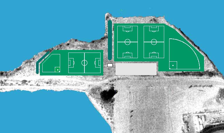
The Albany Plateau
Three full-size soccer/rugby/lacrosse fields (110 meters x 70 meters), one full size baseball/softball diamond and one Little League diamond. The dark green strips are berms for windbreak and spectating to windward of two of the fields. The parking lot holds about 180 cars. The small white square is a 40 ft x 60 structure for bathrooms etc. The entire green playing field areas would be separated from the dog-friendly perimeter trail by an effective fence. Although this would probably be a paved trail, off-leash dogs would be allowed on the Plateau perimeter, including the small beach in the bite on the north side. Five fields might be considered to be too many by some park advocates, but it's a useful exercise to see what a maximized sports field development scenario on the Plateau might look like. |
 |
|
The Albany Bulb
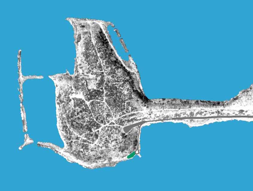
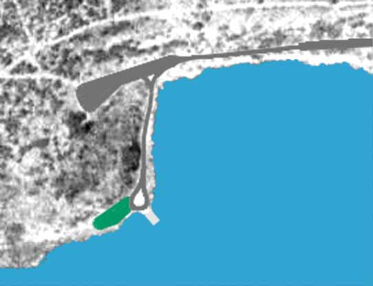
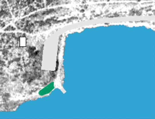
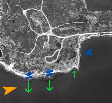
For experienced windsurfers, the SE corner of the Bulb is probably the best launch spot along the entire East Bay shoreline. Windsurfers need vehicular access and a reasonable route to the water. The existing lower road is about 20 ft wide and allows two-way traffic, but there is a short one-lane stretch, A small amount of excavation would be required to widen this part to two lanes. The road leading to the rigging area and launch site would be one-way with a turn-around circle at the end. Sight lines are clear over these short one-way segments, and they should pose no serious circulation problems. Equipment would be dropped off at the rigging area near the tidal steps at the SE corner of the Bulb, and parking would be in the wider gravel area up the hill to the west. |
 |
|
The first detail shows this minimal impact access plan, based on the existing gravel roads. |
 |
|
The second detail shows a paved two-lane road, a much larger paved parking lot, and a bathroom structure and/or interpretave center. This would require significant excavation and utilities installation, but would allow a much broader group of visitors - especially those with mobility problems - to have much easier access to the Bulb. |
 |
|
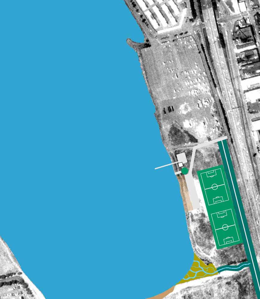
The third detail shows one of several plans promoted by SFBA, the San Francisco Boardsailing Association. This proposal also uses the existing lower gravel road along the neck, but keeps the launch site access road up on top of the hill, out of site from the perimeter trail. It is not clear how much support there is for vehicular access to the Bulb, but this is what it might look like with and without paved roads, and with and without excavation. Vehicular access is one feature that diverges significantly from the 1995 Albany Waterfront Plan. Off-leash dog walking on the Bulb would continue, as per the EBRPD default rules. The lagoon jetty is shown with new cuts in three places, to isolate the SW corner. This becomes a campsite stop on the Water Trail. The remainder of the jetty is isolated by the cuts for bird sanctuary. |
 |
|
The North Basin Strip
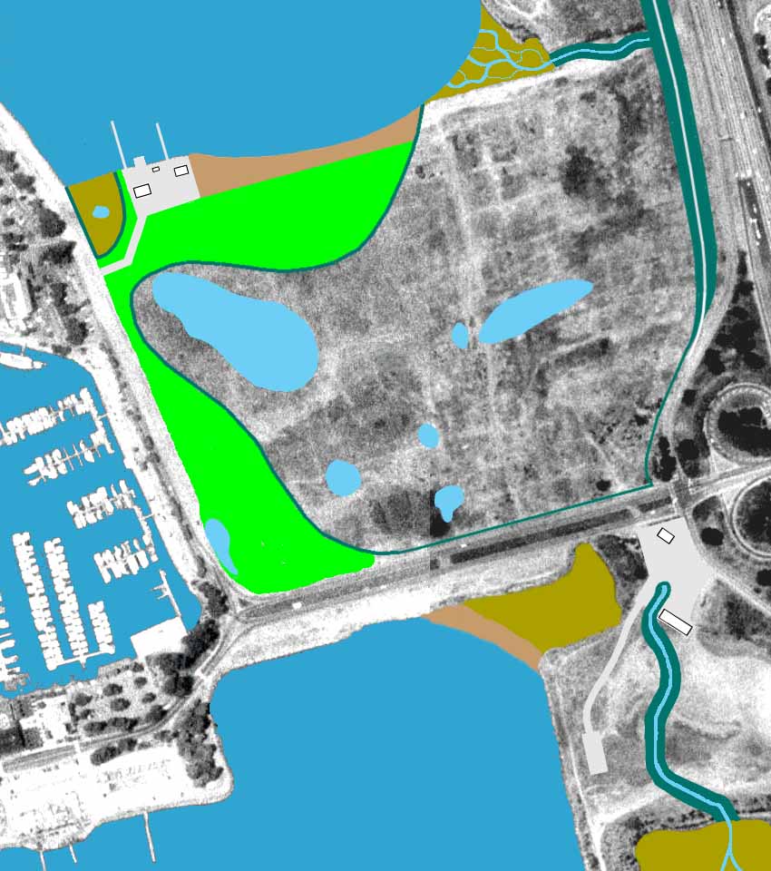
Two more full size soccer/rugby/lacrosse fields are shown, protected from the freeway by a 100 ft wide x 12 ft high earth berm. This allows a slope of about 25%, perfect for spectating, with room for a branch of the Bay Trail on top. The white stripe on top of the berm is the Bay Trail, replacing the trail along frontage road which would be displaced by part of the berm. Another branch of the Bay Trail would run along the shoreline. The parking lot shown holds 90 cars. There's a boathouse and pier from which to run the rowboat rental operation and a possible rowing or kayak club, and also a boat storage area. The tidal steps or ramp is for kayak launching or entry-level windsurfing, and there's a grass rigging area. The beach to the west of the parking lot would be a small off-leash beach. The main thing demonstrated here is that there's plenty of room for a berm, a full width playing field, the Bay Trail, a parking lot and a dog run, all in parallel, without running out of width. |
|
|
The Meadow
The dark green lines represent partial fences or low berms to separate the active recreation areas (light green) from the protected habitat areas. There's still plenty of room in the active areas for a lot of interesting things to happen. The blue areas in the Meadow are existing seasonal ponds, located by informal surveys in January '02. The surface of the large pond on the west side of the Meadow is mostly covered by vegetation, but the others are mostly open water. The small craft facility is slightly smaller than the very active small craft complex at the South Sailing Basin, visible at the lower left corner of the image. A small amount of parking is included in the boating facility, but there would be no public vehicular access to the boat storage area or launching ramp. This ramp is primarily for hand-launched boats and other watercraft stored on site. This is probably a bigger boating facility than would actually be utilized at first, especially considering uncertain funding. The planning goal is only to designate the site for non-motorized public-serving boating activities, so the growth path is available when appropriate user groups and funding appear. For example, this could become a world class venue for dragon boat youth programs and international festival events. There are picnic areas and unstructured fields along the west edge of the Meadow, and a "naturalized" sloping edge along most of the north edge, cut back into the fill if toxicity status permits. This is not a recreational beach in the usual sense, but a softening of the rip-rap edge that will allow easy access to the water without climbing over large rocks. The protected area immediately to the west of the boating facility in the extreme northwest corner of the Meadow is a seasonal marsh with occasional salt water inundation. Parking demand would be met by the existing gravel parking area along the west edge of the Meadow, just outside the park boundary. Dog policy for the Meadow is undetermined. One likely scenario is that dogs would be allowed off-leash in the west section of the Meadow outisde picnic areas and lawns as per EBRPD default rules, but required to be leashed throughout the large estern part of the Meadow. Another option is a seasonal restriction that would prohibit off-leash dogs during the winter months when wildlife is more vulnerable. One alternate plan for the meadow involves bringing both Schoolhouse and Strawberry creeks into the cove to the east of the Brickyard. In the version shown, over 3/4 mile of open creek bed is constructed. |
 |
|
The Brickyard
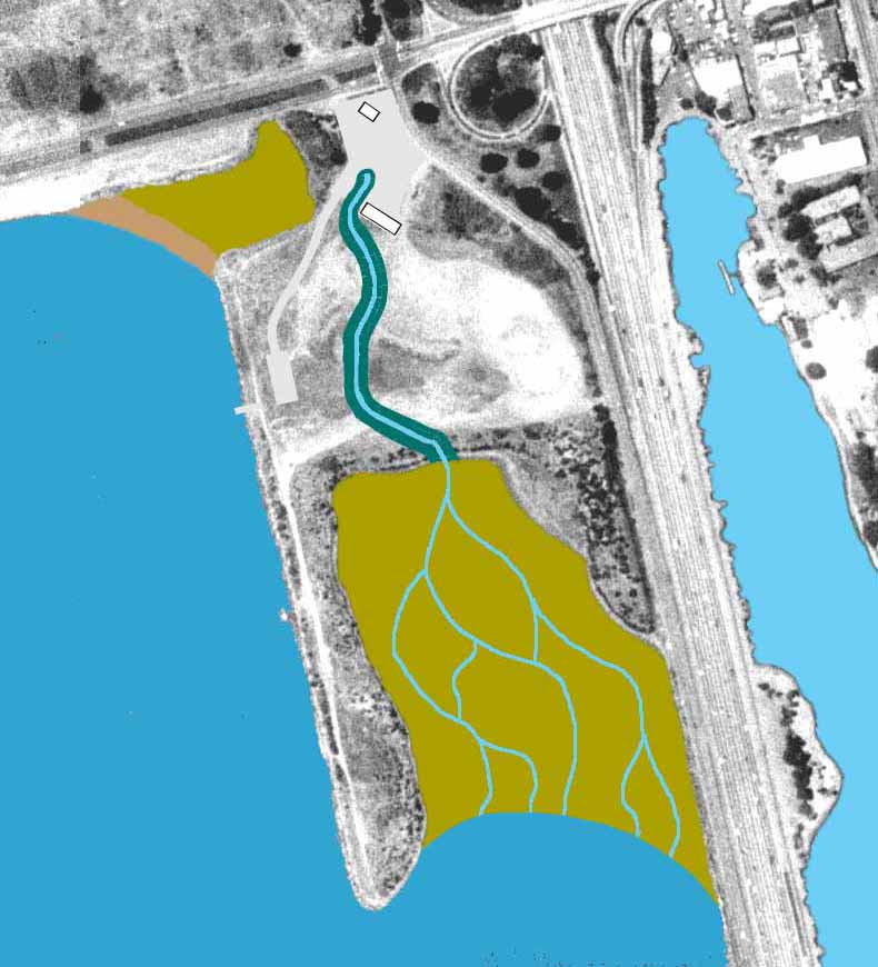
This is a new version of the 1984 plan to re-direct the Strawberry Creek outflow into the tidal flat east of the Brickyard Peninsula. A substantial run of creek could be daylighted, and then filtered by the developing salt marsh before it reaches the Bay. This tidal flat is by far the largest area in the Berkeley portion of the park with a bottom level higher than the MLLW tide datum, and is furthest along in the natural process of becoming a salt marsh. The sketch shows a recreational beach in front of the present Strawberry Creek outflow location, with a wetland or dune area behind it. This is very optimistic considering financial, technical and regulatory obstacles, but should not be ruled out. The goal is to create a stable beach configuration similar to Albany Beach. Seabreeze market is shown exactly the way it is today. The boundaries of the parking lot also reflect current use. The larger building near the creek would be park headquarters and the main visitor/interpretive center. A small parking lot and tidal steps for kayak or sailboard launching is shown further south along the western shoreline. The parking lot at this location holds about 30 cars. Dogs would be prohibited on the Brickyard peninsula due to its high habitat and nature study value, as well as its proximity to the evolving salt marsh. Dog policy on the remainder of the Brickyard would be in accordance with EBRPD default rules. |
|
These site plans are not endorsed by CPAC, the Berkeley Waterfront Commission, or any other advocacy group. However it is believed that they are essentially consistent with the CPAC plan outline and CPAC's priorities for land and water uses in the Eastshore State Park. They are also consistent with land and water use guidelines passed by the Berkeleley Waterfront Commission, and mostly in agreement with the 1995 Albany Waterfront Plan. They are fully consistent with the Berkeley Marina Master Plan and Waterfront Overview nearing completion as of November 2001. These plans are somewhat at odds with recommendations of the Sierra Club and CESP, especially with respect to non-motorized boating activity in the North Sailing Basin. The North Sailing Basin is the only location in the Eastshore State Park that is appropriate for entry-level boating, yet both organizations are on record as opposing the facilities necessary to make this possible. While they will allow limited use of individually owned kayaks and other watercraft, there is no provision in the Sierra Club/CESP plan for youth programs or other public access opportunities usually associated with paddling, rowing, and sailing cooperatives. Even the prospect of seasonal operating restrictions, which would avoid any possibility of interfering with winter diving duck populations, has not softend the Siera Club/CESP position against boating facilities on any part of the Meadow. CESP and the Sierra Club are opposed to continued application of the East Bay Regional Park District dog policy. This policy allows dogs to be off-leash (but under control) in all undeveloped park areas. Dogs must be leashed in parking lots, picnic sites, lawns, developed areas and concession areas. Exceptions are made for special off-leash areas (Point Isabel) and for sensitive no-dog areas (swimming beaches, designated nature study areas, wetlands and marshes). CESP and Sierra Club have called for an end to off-leash access to the Albany Neck and Bulb, all of the Meadow, and a number of other locations shown as remaining off-leash in these site plans. CESP and Sierra Club are also opposed to the inclusion of formal playing fields on the Plateau and North Basin Strip. |